
By SETH BORENSTEIN
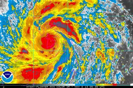
In this image provided by NOAA Friday Nov. 8, 2013 which was taken at 12:30 a.m. EST shows Typhoon Haiyan as it crosses the Philippines. One of the most powerful typhoons ever recorded slammed into the Philippines on Friday, setting off landslides, knocking out power in one entire province and cutting communications in the country’s central region of island provinces. Weather officials say that Haiyan had sustained winds at 235 kilometers (147 miles) per hour, with gusts of 275 kph (170 mph) when it made landfall. (AP Photo/NOAA)
Philippines Typhoon
Residents sift through the rubble of their damaged house following a powerful typhoon that hit Tacloban city, in Leyte province, central Philippines Saturday, Nov. 9, 2013. The central Philippine city of Tacloban was in ruins Saturday, a day after being ravaged by Typhoon Haiyan, one of the strongest typhoons on record, as horrified residents spoke of storm surges as high as trees and authorities said they were expecting a “very high number of fatalities.” (AP Photo/Bullit Marquez)
Prev
1 of 2
Next
WASHINGTON (AP) — A powerful typhoon hit the Philippines on Friday and was heading Saturday toward Vietnam. Facts about typhoons:
HURRICANE? CYCLONE? TYPHOON? They’re all the same, officially tropical cyclones. But they just use distinctive terms for a storm in different parts of the world. Hurricane is used in the Atlantic, Caribbean Sea, central and northeast Pacific. They are typhoons in the northwest Pacific. In the Bay of Bengal and the Arabia Sea, they are called cyclones. Tropical cyclone is used in the southwest India Ocean; in the southwestern Pacific and southeastern India Ocean they are severe tropical cyclones.
STRENGTH: A storm gets a name and is considered a tropical storm at 39 mph (63 kph). It becomes a hurricane, typhoon, tropical cyclone, or cyclone at 74 mph (119 kph). There are five strength categories, depending on wind speed. The highest category is 5 and that’s above 155 mph (249 kph). Australia has a different system for categorizing storm strength.
ROTATION: If they are north of the equator they rotate counterclockwise. If they are south, they rotate clockwise.
SEASON: The Atlantic and central Pacific hurricane seasons are June 1 through Nov. 30. Eastern Pacific: May 15 to Nov. 30; northwestern Pacific season is close to all year, with the most from May to November. The cyclone season in the south Pacific and Australia runs from November to April. The Bay of Bengal has two seasons April to June and September to November.
WHERE IS THE BUSIEST PLACE? The northwestern Pacific where Typhoon Haiyan has just hit. A normal year there involves 27 named storms. Haiyan is the 28th named storm and there has already been a 29th. By comparison the Atlantic averages 11 named storms a year and this year there have been 12, none of them causing major problems.
WHO DECIDES THE NAMES? The lists are maintained by the World Meteorological Organization; the names are ones that are familiar in each region. Names are taken off the list and replaced to avoid confusion if a hurricane causes a lot of damage or deaths. For example, Katrina was retired after it devastated New Orleans in 2005. The Philippines has its own naming system, so Typhoon Haiyan is also being called Yolanda.
HOW DOES EL NINO AFFECT STORMS? During an El Nino — when the central Pacific is warming — there are fewer Atlantic storms. El Ninos shift where storms form, but not the number, for the northwest Pacific and the southwest Pacific. The central Pacific gets more storms during El Nino and the year after. This year has neither an El Nino nor its opposite, a La Nina. It is a neutral year.